Abdullah Al Saim

Welcome to my website!

I'm a PhD Candidate in Geosciences at the University of Arkansas, specializing in GIS and Remote Sensing. My research focuses on forest classification and biomass estimation from multi-source satellite imagery using machine learning. With a background in Geography and Environmental Sciences, I bring a blend of academic rigor and hands-on experience to my work. I am passionate about GIS and enjoy leveraging data to craft meaningful and impactful maps and drive innovation in the geospatial realm.

@AbdullahAlSaim

Modeling Wildfire Susceptibility For Arkansas

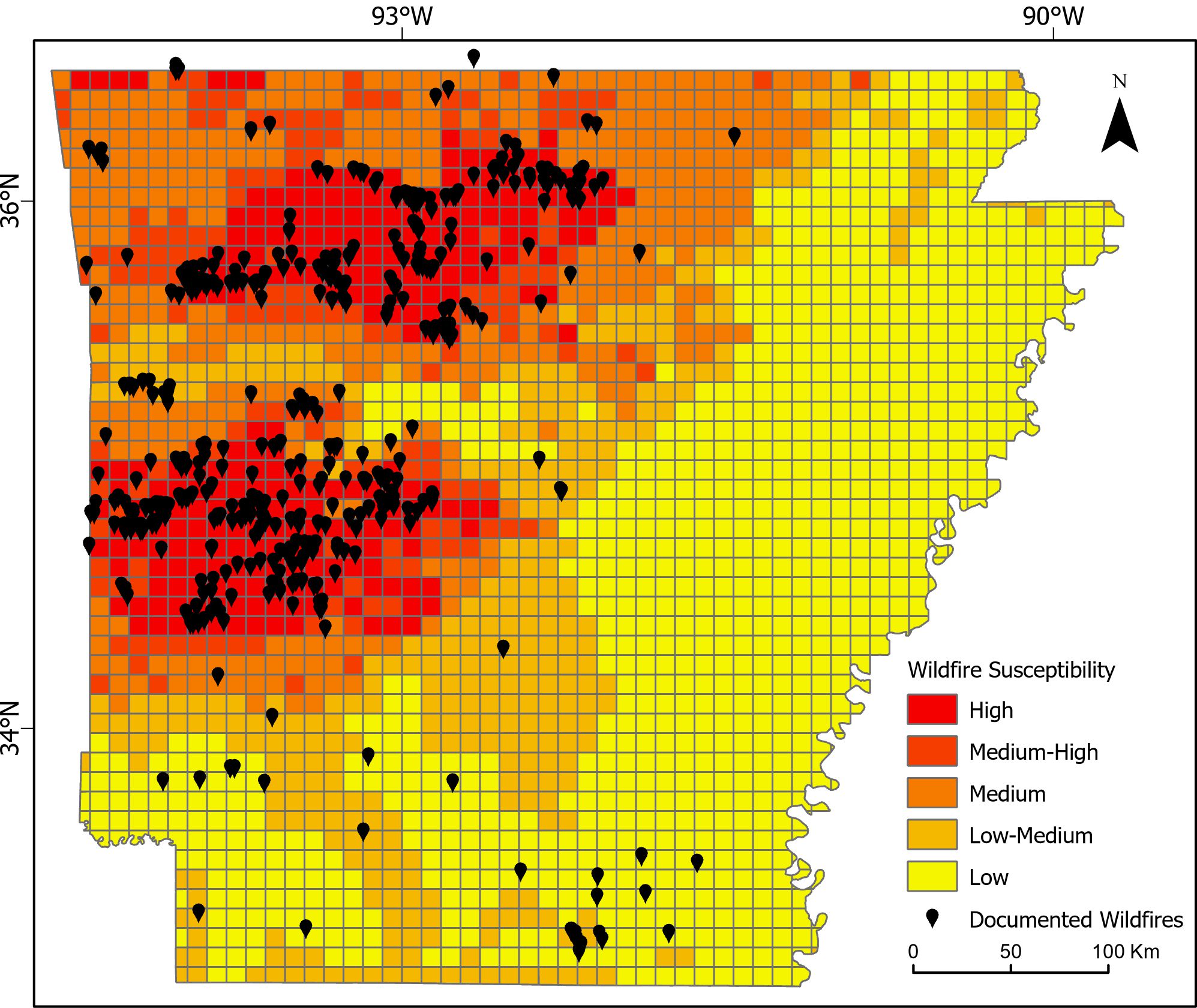
Fire susceptibility modeling is essential for protecting forests, especially in Arkansas, where trees cover over half the state. The study used satellite data and machine learning algorithms to understand what factors contribute to wildfires in Arkansas. We found that precipitation, soil moisture, and drought index are the most important variables affecting wildfire susceptibility. We discovered that certain areas, like the Ouachita National Forest and the Ozark Forest, are at higher risk. This information can help us better prepare for wildfires and protect our environment.

Air Pollution Due To Wildfires

California has a history of severe wildfires, leading to heavy air pollution. This study examined the impact of wildfires on air quality from 2010 to 2020 using advanced satellite technology and cloud computing. Satellite data from MODIS MAIAC and Sentinel-5P were analyzed to measure Aerosol Optical Depth (AOD) and nitrogen dioxide (NO2) levels. The study found a significant increase in AOD during wildfire events and an increasing trend in AOD level. Sentinel-5P data showed a substantial increase in NO2 concentration during the major wildfires. These findings can inform decision-making and improve California's wildfire prevention and mitigation efforts.

Forest Classification From Multisource Satellite Data

Arkansas' subtropical climate nurtures extensive forested regions, particularly within the Ozark- St. Francis and Ouachita National Forests. Despite this, the state lacks an up-to-date, high-resolution map detailing tree species distribution within its forests. This study harnesses the power of machine learning, cloud computing framework, and multisource satellite data to produce an up-to-date high-resolution forest classification map.

Cartography

The Relative Elevation Model (REM) is vital for visualizing floodplains and understanding fluvial landforms. By detrending a Digital Elevation Model (DEM) based on the water surface of a stream, REM generates Height Above River (HAR) rasters that highlight features otherwise challenging to determine. These rasters, normalized to the elevation of a channel, enhance the visualization of relics such as stream channels, meander scrolls, and floodplain surfaces, which are crucial for channel migration studies, flood assessments, and habitat evaluations. REM provides invaluable insights into the dynamics of river systems and aids in making informed decisions in environmental management and engineering projects. Lastly, they are stunning to look at!

Google Earth Engine App

This Earth Engine application offers a comprehensive view of global environmental dynamics. The app displays monthly averages of Night Time Data, NDVI (Normalized Difference Vegetation Index), and Land Surface Temperature by leveraging VIIRS and MODIS images. It is a powerful tool for understanding the interplay between urbanization, vegetation health, and land surface temperature patterns worldwide from 2014 to 2023. Check it out for an insightful exploration of our planet's changing landscapes!

Publications

Saim, Abdullah Al, and Mohamed H. Aly. "Big data analyses for determining the spatio-temporal trends of air pollution due to wildfires in California using Google Earth Engine." Atmospheric Pollution Research 15.9 (2024): 102226.

Saim, A.A. and Aly, M.H., 2022, Machine Learning for Modeling Wildfire Susceptibility at the State Level: An Example from Arkansas, USA. Geographies, 2(1), 31–47, Special Issue: Applying Remotely Sensed Imagery in Natural Resource Management, https://doi.org/10.3390/geographies2010004

Saim, A. A., & Rahman, S. H. (2021). Impacts of Climate Change on Dry Season Flow of Gorai River, Bangladesh Using SWAT Model. Bangladesh Journal of Environmental Research, 12, 20–36

Conference Presentations

Saim, A. and Aly, M.H., 2024, Enhancing Tree Species Mapping in Arkansas' Forests through Machine Learning and Satellite Data Fusion: A Google Earth Engine-Based Approach, American Association of Geographers (AAG), Honolulu, Hawaii, April 16–20, 2024.

Saim, A. and Aly, M.H., 2022, Spatio-Temporal Trends of Air Pollution due to Wildfires in California: Inferred from MODIS MAIAC and SENTINEL-5P, Geological Society of America Abstracts with Programs. vol. 54, no. 4, doi: 10.1130/abs/2022NC-374658.

Saim, A. and Aly, M.H., 2021, Modeling Wildfire Susceptibility in Arkansas using GIS-based Multiple Regression and Random Forest, GSA 2021 North-central/South-Central Joint Section Meeting, Springfield, MO, April 18-20, 2021, vol. 53(3), doi: 10.1130/abs/2021NC-362686

Get In Touch

Let's connect! Whether you have questions, feedback, or collaboration ideas, I am all ears. Drop me a message via the contact form or connect on LinkedIn. I look forward to hearing from you!